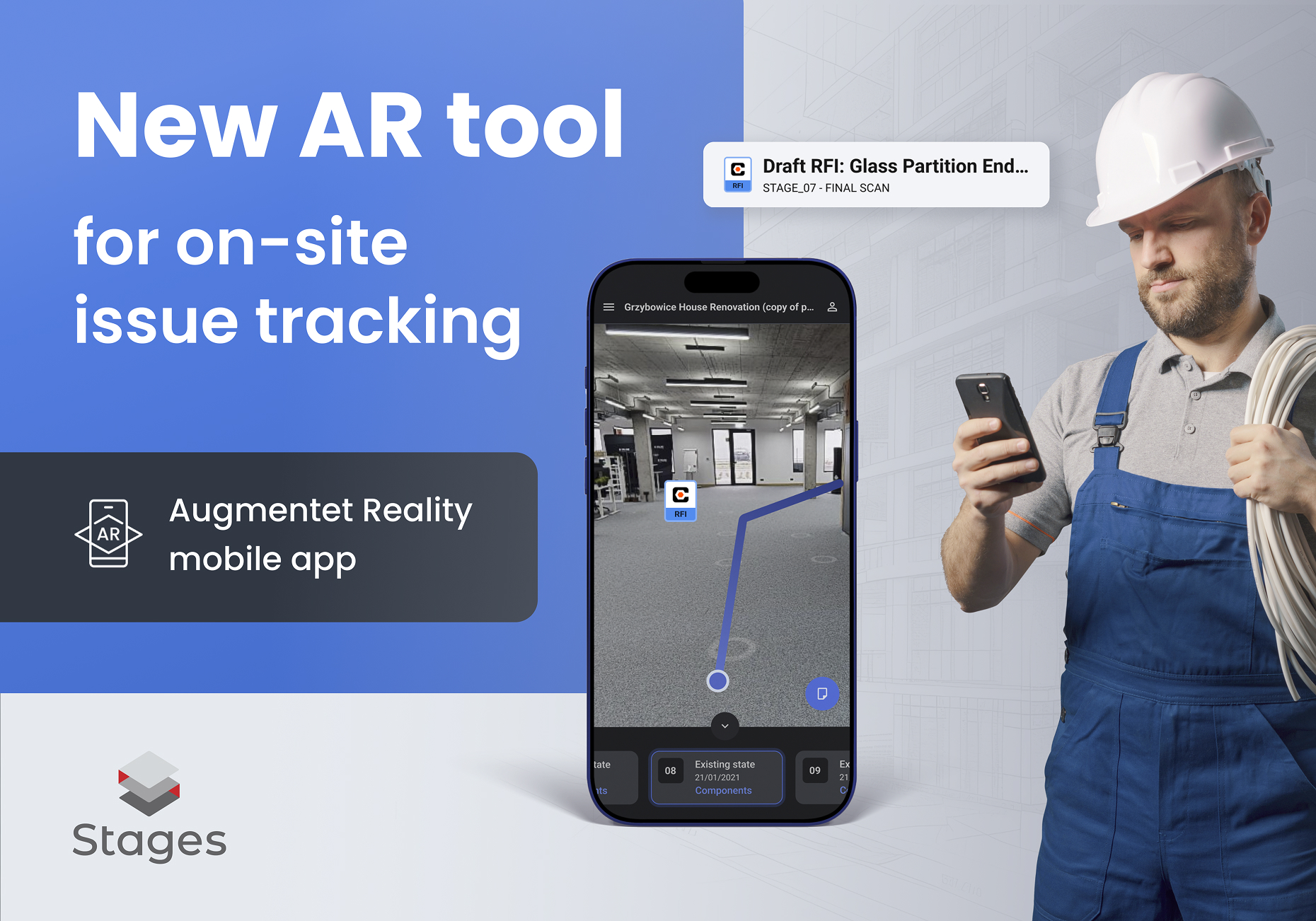
Three things matter most in construction management, facilities operations, and field maintenance: context, precision, and time. STAGES AR for Android is designed for exactly that. It’s a native Android application (not a mobile browser feature) that communicates directly with the STAGES backend. Powered by the AR engine, it builds its own local 3D model from MatterPak point clouds or a Matterport mesh (.obj) and uses that model to accurately localize markers in physical space. Once you’re on site, the app can guide you along an AR path to each note’s real-world location, where you can view, edit, and create notes, including attaching screenshot annotations for crystal-clear handoffs.
Below you’ll find a deep dive into how the solution works, where it shines, and how teams across FM/EAM/BMS, development, ownership, and Matterport Service Providers can deploy it for quick, repeatable wins.
Why a Native Android App (and Not AR in a Browser)?
Choosing a native app for AR isn’t cosmetic-it’s fundamental to how precisely and reliably the system performs.
- Performance & Stability: Native rendering and direct access to device sensors (camera, IMU) reduce latency and improve tracking stability. The experience is smoother, more trustworthy, and less prone to drift.
- Tight Control of the Data Pipeline: STAGES AR builds a local 3D model from MatterPak point clouds or a Matterport mesh (.obj) and aligns that model to the real environment. That’s a more robust and repeatable method than lightweight browser overlays.
- Deeper Backend Integration: The app communicates directly with the STAGES backend to fetch markers/notes and to sync updates. You get consistency across teams and a reliable audit trail as work progresses.
The result is marker localization you can trust, with fewer misplacements, less confusion, and strong performance in large or complex spaces.
How It Works: An Architecture Overview
- Secure Connection to the STAGES Backend
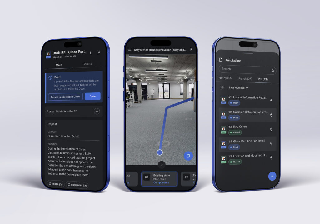
After signing in, the user selects a project and stage. The app retrieves structures from the backend: notes, markers, relationships (e.g., with Procore Punch items / RFI), and the assets needed to reconstruct the scene on the device. - Local 3D Model Construction
The AR engine creates a working 3D model from MatterPak point clouds or mesh (.obj). (The .obj is available within the MatterPak.) Instead of approximations, STAGES AR uses a mathematically grounded, locally built reference of the site. - Marker Localization & AR Path Guidance
With that model, the app localizes markers in the real world and renders a guiding AR path to each note’s exact location. Every technician is directed to the same physical point, eliminating the usual “it’s somewhere near here” guessing game. - On-Site Workflows
At the note location, users can view details, edit, or create new notes. They can capture screenshot annotations (drawings, arrows, callouts) and attach them to the note. All updates sync back to STAGES for use in the web interface, dashboards, and reports.
What You Gain in Practice
1) Find Information Exactly Where It Lives
Instead of scanning lists and guessing locations, you follow a visual AR path to the precise spot. Travel time shrinks, handoffs become cleaner, and first-time visitors navigate confidently.
2) Edit and Create Notes in Context
Being physically present at the note location removes ambiguity. You capture the real state of the asset or space while it’s in front of you, not later from memory.
3) Screenshot for Unambiguous Communication
A quick snapshot with overlaid freehand brush annotations conveys expectations and findings fast. Visual cues reduce misinterpretation and eliminate back-and-forth.
4) Alignment with Procore Punch/RFI
If you work with Procore, STAGES can connect note/marker workflows with Punch items and RFI, integrating the spatial context with your project control process.
5) One Source of Truth
Because everything syncs through the STAGES backend, field updates, web review, and reporting all reflect the same reality, grounded in real-world coordinates and a consistent model.
When STAGES AR Makes the Biggest Difference
- Inspections & Site Acceptance: Arrive at each inspection point with turn-by-turn AR guidance and record evidence where it matters-on location.
- Cross-Trade Coordination: When schedules are tight, flawless navigation to the correct spot keeps crews moving and minimizes rework.
- Facilities Maintenance: Locate assets, issues, and service points by actual physical coordinates, not by descriptions like “near the C3 junction.”
- Punch-List Corrections: Tie visual proof and precise location to each corrective task; everyone speaks the same spatial language.
- Onboarding New Teams: New hires or subcontractors ramp up quickly with AR paths that lead them straight to the work.
A Day in the Field: Example Workflow
- Morning Planning: The site manager selects control points in STAGES and assigns them to a technician.
- Start AR Session: The technician opens the native STAGES AR app on Android, signs in, and loads the project with markers.
- Navigate: The app renders an AR path to the first note-no wandering, no radio calls.
- Verify & Annotate: At the location, the technician edits or completes the note, adds a screenshot + brush with quick markups (arrows, outlines), and includes a short instruction.
- Sync: Saving pushes updates to the STAGES backend immediately. If the note is tied to Punch/RFI, the connected record can reflect the change.
- Repeat: Move to the next marker, guided by AR. Work proceeds efficiently and predictably.
Who Benefits Most?
- Property Owners & Asset Managers who need visibility into real progress and locations of issues.
- Developers & General Contractors aiming to compress decision cycles and reduce site miscommunication.
- Matterport Service Providers (MSP) looking to extend beyond scans into spatially aware workflows based on MatterPak.
- FM/EAM/BMS Teams standardizing an on-site process that any technician can follow, right from an Android device.
Requirements and Implementation Tips
- Platform: Android (native app, not a browser experience).
- Input Data: MatterPak component in Stages, used by AR engine to build the local model for precise localization.
- Connectivity: The app communicates with the STAGES backend for authentication, data retrieval, and syncing changes; network access is required.
- Permissions: Camera and motion sensors must be enabled for robust AR tracking.
- Rollout Approach: Pilot on a single site, deliver a 10–20-minute hands-on training, and standardize note/marker naming so teams search consistently.
Best Practices for Note Workflows
- Establish a Shared Vocabulary
Create a common set of tags and categories for the site. Consistent naming makes search, filtering, and reporting straightforward. - Capture While You’re There
Use the “see it → describe it → mark it” rule. If you’re at the location, update the note now and attach a screenshot. Don’t postpone and risk losing detail. - Make Visuals the Default
A picture with a few markups often beats a long paragraph. Use arrows, circles, and short callouts to prevent misinterpretation. - Sync Habitually
Save updates as you go. Office teams and subsequent shifts then work from the same, current data without delays.
Data Security, Roles, and Consistency
STAGES AR isn’t a standalone island. It’s part of the STAGES ecosystem:
- Users authenticate and access only authorized projects and stages.
- The app communicates directly with the STAGES; there’s no ad-hoc, unmanaged data store.
- Role-based permissions ensure people modify only what they’re allowed to, preserving data integrity and accountability.
FAQ
Does STAGES AR run in a mobile browser?
No. It’s a native Android application-that’s how it achieves the required AR stability and precision.
How does the app know where to place markers?
The AR engine builds a local 3D model from MatterPak point clouds or a Matterport mesh (.obj) and aligns that virtual model to the real environment. Markers are then localized and rendered precisely in AR.
Can I tie my field work to Punch/RFI?
Yes. Through STAGES, notes and markers can be associated with Procore Punch items and RFIs, so spatial context and project control remain in lockstep.
Can I draw on the scene?
Yes. Use screenshot + brush to capture the scene and add freehand annotations that become part of the note record.
Summary
STAGES AR for Android moves note work into native AR anchored by a local, mathematically grounded 3D model built from MatterPak point clouds or Matterport mesh (.obj). That anchor enables precise marker localization, clear AR pathfinding on site, and simple, visual documentation via screenshot. Because all changes flow through the STAGES backend, teams share a single source of truth – from field inspection and corrective actions to reporting and Punch/RFI closeout.
If your goal is to shorten the path from problem to resolution and standardize how teams operate in the field, STAGES AR delivers where it counts most: at the exact point of work.